Help WA Petroleum & Geothermal Information Management System
Overview of WAPIMS
WAPIMS releases all information arising out of petroleum exploration activities within Western Australia’s State jurisdiction (onshore and State waters) together with Commonwealth area activities with the release date prior to 1 January 2012.
WAPIMS also contains up to date information on Commonwealth mineral samples
How to use WAPIMS
Step 1 Search
Search the Petroleum Exploration database using the search form on the homepage, or by selecting a search category from the search dropdown in the main menu.
- Select the Category you want to search within eg: Wells
- Click Search to return a list of results
Step 2 List of results
You will now have a number of results based on your search criteria
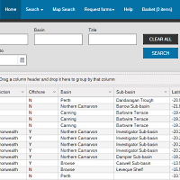
Refine Search
You can refine your search further using the fields available
- Drag column headers into the top left bar to sort by sort by columns
- Click Search to return a list of results
Rearrange
- Rearrange your columns by dragging column headers and dropping them into the grouping region at the top left of the grid
- Rearrange and reorder by columns
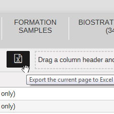
Export to Excel
- Export your results to excel using the Excel button
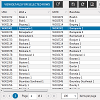
View details
- To view details for rows, select multiple rows by clicking and holding the Ctrl key, then click View Details for Selected Rows
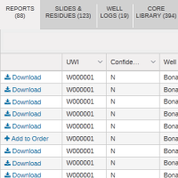
Step 3 Viewing Details
You will now see a catalogue of available information for the rows you selected in the previous screen.
Accessing information
Information is available for access in three channels
- Download Documents available for immediate download. You will see a
- Add to Order Documents available for order. You will need to add these to your basket using the button.
Rearrange
- Rearrange your columns by dragging column headers and dropping them into the grouping region at the top left of the grid
- Rearrange and reorder by columns
Export to Excel
- Export your results to excel using the Excel button
Map Search
You can search the Petroleum Exploration Database spatially using the interactive Map Search Tool.
Step 1 Search
Zoom into an area by clicking on the Zoom In button, or by using the scroll wheel on your mouse.
- Click and then drag the area of interest on the map.
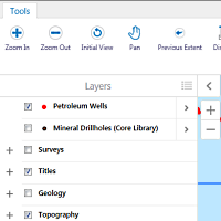
- Select the Layers you wish to show on the map.
- Click the Identify button and select an area to return a list of results
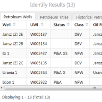
Step 2 Results
You will now have a number of results based on your selection.
- Click on the relevant tab to view Wells, Titles, Surveys etc
- Click the row to highlight the location on the map.
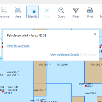
Step 3 Viewing Details
You will now have a number of results based on your selection.
- Click the View in WAPIMS link to view the data and documents relating to that relevant search
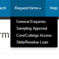
Request Forms
There are several online forms available for requesting information. These can be found under the "Request Forms" menu.
Step 1 Find the relevant form
To find the request form you need click on Request Forms, in the main menu.
- Select the request form you need form the drop down list. eg: Core/Cuttings Access etc
- Complete your personal details. These are required to process the request.
Step 2 Complete the Request
After providing your personal and contact details each form will have different fields, that will be required to be completed.
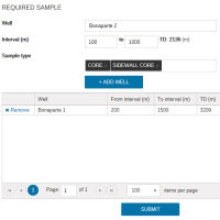
Cores and Cuttings
- Under the Required Sample section enter in the Well Name where the core is located. (If the well name does not appear just enter the well where you believe it is located)
- Enter the Internal from and to in metres. (If the well was found in the database automatically the total depth will be displayed next to these fields
- Choose the Sample Type from the drop down list.
- Click Add Well to add this list to the Grid.
- You can also remove wells from the grid by clicking on Remove
- Click on Submit once you would like to finalise your request. A copy of the request will be emailed to you along with a reference number.